 Analysis byWeUseApps
When I use a hunting map in the field, I need to understand it quickly, not wrestle with a screen while watching my footing or checking where a boundary runs. onX Hunt is built around that practical problem: it brings map reading, GPS navigation, property boundaries, and hunting-related layers together. I find it most useful as a planning and orientation tool, especially for people who want to prepare at home and then carry the same map into the outdoors.
Reading the map before and during a hunt
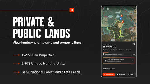
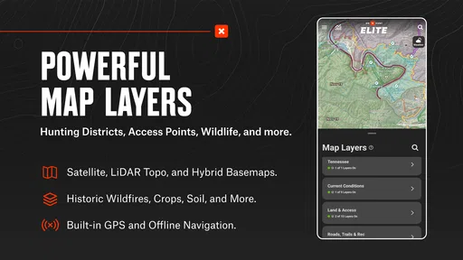
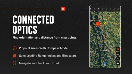
The app’s strongest idea is the way it puts several kinds of geographic context in one place. Topographic information helps me think about terrain, while property lines make it easier to assess where access may be appropriate. GPS navigation gives those map details a real-world reference point. Rather than switching between a general map, a separate boundary resource, and handwritten notes, I can use one hunting-focused view to build a clearer picture of an area.
That does not mean the map makes decisions for me. A boundary line on a screen is a planning aid, not permission to cross land or a substitute for checking current local rules. I treat it as a way to identify questions before I go: where a route might lead, which terrain features matter, and whether I need to verify access with a landowner or another reliable source.
A useful workflow is to review the area while I have time and a larger screen available, then simplify what I expect to check in the field. I would mark the likely approach in my mind, note important terrain transitions, and avoid trying to inspect every layer while moving. This reduces visual clutter and makes the map more useful when attention needs to stay on the surroundings.
For someone new to hunting maps, the advantage is not simply having more information. It is being able to compare information that would otherwise be scattered across different tools. For an experienced hunter, the value is more about efficiency: property context and terrain can be considered together instead of reconstructed from memory. Neither user should assume that a detailed map replaces scouting or judgment on the ground.
The product is a sports app from onXmaps, and its focus is noticeably narrower than that of a general navigation app. That specialization is a strength when I am planning a hunt, but it also means people looking for everyday driving directions or broad travel planning may find a general map more natural. The best fit is someone who regularly needs hunting-specific geographic context, not simply anyone who wants a map on a phone.
Navigation that works best with preparation
GPS is most helpful when I already know what I want to check. On a hunt, I might use it to relate my position to a planned route or a property edge, then pause to confirm the surrounding terrain. This is different from following turn-by-turn instructions in a car. The app can help me orient myself, but I still need to interpret the land, keep track of changing conditions, and choose a safe route.
Because the app is associated with offline hunting maps, preparing before leaving service is an important habit. I would make sure the area I expect to use is ready for offline access before heading out, rather than discovering in the field that I have not prepared the map. Offline planning is especially relevant in remote places, but it should not create false confidence: a downloaded map does not guarantee that every detail is current or that the phone will have power throughout a long day.
One less obvious benefit of a layered map is that I can use it to compare routes rather than just identify a destination. A direct line may cross steep terrain or approach a boundary in an awkward way, while a longer route may be easier to follow. Looking at the terrain and property context together helps me ask that question before I am tired, hurried, or navigating in poor light.
Screen use, movement, and sensory demands
For readability, the main advantage is having map information organized around a visual view of the landscape. But map reading remains a visual task. Small details, layered markings, and a busy screen can take time to interpret, especially in bright sunlight, while wearing gloves, or when the user has low vision. I would test the display at home and learn the controls before relying on it outdoors, rather than assuming every label will be easy to read in every condition.
There is also a meaningful difference between checking a map while stationary and using it while walking. I would stop somewhere safe before zooming, changing layers, or inspecting a boundary. That habit is useful for anyone, and especially for people with limited balance, mobility, or coordination. Looking down at a phone while crossing uneven ground raises a practical safety concern regardless of how good the map is.
Touchscreen interaction can also be a source of friction. A person with reduced dexterity may find repeated pinching, tapping, or switching between map views tiring. Gloves and cold conditions can make that harder. My practical approach would be to set up the map in advance, keep field checks brief, and avoid depending on fine finger movements when conditions are uncomfortable. The app’s mapping purpose is clear, but it does not remove the physical demands of operating a phone outdoors.
Sensory context matters too. A phone screen can compete with sounds and visual cues that are important in the field. I would keep checks deliberate and brief, then put the device away and return attention to the environment. People who find screens distracting, or who rely heavily on hearing and sight to stay oriented, may prefer to combine the app with a printed map or another familiar navigation method.
Access across different places and routines
In an everyday planning scenario, I might review a potential hunting area at home, compare its terrain with the property context, and decide what I need to verify before traveling. Once there, I can use the phone to check my position at a safe stopping point rather than repeatedly consulting it on the move. This split between deliberate preparation and occasional field use is where I think the app makes the most sense.
The offline aspect is relevant for anyone who hunts where mobile service is unreliable. It can make a prepared map useful beyond the reach of a steady connection, but it does not turn the phone into a rugged navigation device. Battery life, weather protection, screen visibility, and the user’s ability to handle the device remain part of the equation. A paper backup is still sensible for a long or unfamiliar outing, particularly if getting lost would have serious consequences.
The app is free to install, with in-app purchases ranging from $9.99 to $99.99 per item. I would think about the cost in terms of how often I hunt and whether the available mapping tools match my usual needs, rather than paying simply because a feature sounds useful. Someone who hunts only occasionally may be better served by checking what they can do without a purchase first. A frequent hunter who depends on detailed preparation may find the investment easier to justify, but should still assess the specific options in the app before spending.
onX Hunt has an average rating of 4.5 from around 65,000 ratings, and it has been installed over five million times. Those figures suggest a substantial audience, but they do not tell me whether the interface will suit a particular person or whether its maps fit a particular region. I would judge it by testing the workflow that matters to me: finding an area, understanding its boundaries, preparing for offline use, and reading the map comfortably.
Where it can still be difficult
The biggest limitation is that a map cannot settle every question that arises outdoors. Property information and terrain are useful context, but responsible access still depends on real-world conditions and applicable rules. Boundaries can be difficult to interpret when a screen is small or the landscape is unfamiliar, so I would avoid treating a line as unquestionable proof of where I may go. When access is uncertain, checking directly is the safer choice.
Another trade-off is complexity. Combining map layers gives the app its hunting focus, yet every additional layer can make the display harder to scan. New users may need time to learn which information helps them and which is visual noise for a particular trip. I would start with a simple view, add only the layers that answer a clear question, and practice before relying on the app under pressure.
It is also not the right primary tool for everyone. A person who needs large, high-contrast text, hands-free directions, or a screen-free way to navigate should not assume this app alone will meet those needs. Someone with limited phone access or a preference for paper maps may be more comfortable using a printed map as the main reference and the app as a secondary check. That is not a failure of the app so much as a reminder that field navigation is personal and often benefits from backup options.
onX Hunt is rated for Everyone, and it first appeared on November 8, 2013. It supports Android 8.0 and later. Those details help establish basic compatibility, but the practical question is whether a particular phone is comfortable to use outdoors and whether the user can prepare and read maps with confidence. I would install it and learn its map controls in a familiar setting before depending on it in an unfamiliar one.
Who I would recommend it to
I would recommend onX Hunt to hunters who want to bring terrain, property context, and GPS orientation into the same planning routine. It is especially appealing if you scout new areas, prepare for trips where service may be limited, or want to compare possible approaches before setting out. Its focused design is more useful for those tasks than a general-purpose map that lacks the same hunting context.
I would be more cautious if you rarely hunt, mainly need basic directions, or have accessibility needs that make a small touchscreen difficult to operate. In those cases, a general map, a paper reference, or a combination of tools may be more comfortable. Whatever option you choose, it is worth testing it before the trip and keeping your attention on the terrain rather than the screen.
My overall view is that this is a capable planning companion, not an all-purpose answer to field navigation. Its most inclusive use comes from adapting the workflow: prepare maps in advance, keep the display uncluttered, stop before interacting, and carry a backup when the outing calls for one. If that approach fits how you hunt, this app can make geographic information easier to bring together. If it does not, choosing a simpler or more accessible reference is the sensible call.
What we like
- Detailed land ownership maps help identify property boundaries.
- Offline maps remain accessible in areas with poor cell service.
- Custom waypoints make it easy to mark trails and hunting spots.
- Layer options show useful terrain and public land information.
- Track recording helps document routes and outings.
What could be better
- Many advanced map layers require a paid subscription.
- Offline map downloads can use substantial phone storage.
- Ownership details may not reflect the latest changes.
- Battery use can increase during long GPS-tracked trips.
- Map data and features vary by location.